Detail View: Charting The Nation: [A map of Strath Devon and the district between the Ochils and the Forth] [1 of 1]
|
Work Record ID:
|
0042691
|
|
Shelfmark:
|
Adv.MS.70.2.11 (Adair 5)
|
|
Holding Institution:
|
National Library of Scotland
|
|
Title:
|
[A map of Strath Devon and the district between the Ochils and the Forth]
|
|
Creator:
|
Adair, John (b.1660, d.1718)
|
|
Creator Role:
|
Mapmaker
|
|
Date:
|
1681
|
|
Description:
|
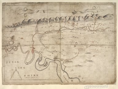
This untitled manuscript map by John Adair of the area lying between the Ochil Hills and the Forth estuary was prepared as proof to the Privy Council of his cartographic ability. Although it delineates the turnings of the Forth, it is much less detailed in showing its riparian (river bank) features, which contrasts with the careful mapping of the Hillfoot settlements. Unfortunately, the sketch of Stirling which lies at right angles to the map has been damaged. Unlike his other manuscripts, towns, such as Alloa, are not shown in plan form but by diagrammatic sketches more akin to the work of Timothy Pont. The elegant compasses of the scale bar and empty banner title field suggest this may be a final draft.
|
|
Work Type:
|
Manuscript map/plan
|
|
Measurement:
|
50 x 33.6cm (1' 7 11/16" x 1' 1 1/4")
|
|
Material:
|
Paper
|
|
Technique:
|
Pen and ink
|
|
Subject Place:
|
Clackmannanshire
|
|
Subject Place:
|
Scotland
|
|
Reference:
|
Taylor, Alexander B., 'Manuscript maps of Pont, the Gordons and Adair in the Advocates' Library, Edinburgh',Scottish Geographical Magazine, Nov., 1907, pp.591-592.
|
|
Reference:
|
Moir, D.G., Early maps of Scotland, v.2, 1983, p.179.
|
|
Rights Statement:
|
© 2002 The National Library of Scotland
|
|
Repro File Type:
|
Cropped Tiff
|
|
Repro File Size (bytes):
|
102363404
|
|
Repro Title:
|
[A map of Strath Devon and the district between the Ochils and the Forth] [1 of 1]
|
|
Repro Display Measurement (pixels):
|
7072 x 7072
|
|
Repro ID Number:
|
0042691c.tif
|
|
Repro Old ID Number:
|
00001011
|
|
Repro Capture Date:
|
04/08/2000 12:20:00
|