Detail View: Charting The Nation: Lennox, Argyle. [1 of 1]
|
Work Record ID:
|
0042415
|
|
Shelfmark:
|
Adv.MS.70.2.10 (Gordon 49)
|
|
Holding Institution:
|
National Library of Scotland
|
|
Title:
|
Lennox, Argyle.
|
|
Creator:
|
Pont, Timothy (b.1564, d.Circa 1614)
|
|
Creator Role:
|
Surveyor
|
|
Creator:
|
Gordon, Robert (b.1580, d.1661)
|
|
Creator Role:
|
Mapmaker
|
|
Date:
|
1634-1655
|
|
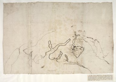
Description:
|
A small scale map extending from Kintyre and Loch Fyne in the west to the head of the Firth of Forth in the east, as far south as Glasgow and as far north as Ben Lui. In the west, even the coastline is drawn only tentatively and the location of the Gare Loch was altered by the author. The only significant detail is in the vicinity of Loch Lomond. The map is an uncompleted draft compiled by Robert Gordon of Straloch (1580-1661), at an unknown date after 1633. The main source of the compilation is likely to be the observations of Timothy Pont, in the last two decades of the sixteenth century.
|
|
Work Type:
|
Manuscript map/plan
|
|
Measurement:
|
48.7 x 31.5cm (1' 7 3/16" x 1' 3/8")
|
|
Material:
|
Paper
|
|
Technique:
|
Pen and ink
|
|
Subject Place:
|
Argyll and Bute
|
|
Subject Place:
|
Scotland
|
|
Subject Place:
|
Stirlingshire
|
|
Reference:
|
Taylor, Alexander B., 'Manuscript maps of Pont, the Gordons and Adair in the Advocates' Library, Edinburgh',Scottish Geographical Magazine, Nov., 1907, p.589.
|
|
Rights Statement:
|
Courtesy of the Keeper of the Records of Scotland
|
|
Repro File Type:
|
Cropped Tiff
|
|
Repro File Size (bytes):
|
83977346
|
|
Repro Notes:
|
49
|
|
Repro Title:
|
Lennox, Argyle. [1 of 1]
|
|
Repro Display Measurement (pixels):
|
7072 x 7072
|
|
Repro ID Number:
|
0042415c.tif
|
|
Repro Old ID Number:
|
00000671
|
|
Repro Capture Date:
|
27/06/2000 14:05:00
|