Detail View: Charting The Nation: Lochabre Glencooen [1 of 2]
|
Work Record ID:
|
0042401
|
|
Shelfmark:
|
Adv.MS.70.2.10 (Gordon 37)
|
|
Holding Institution:
|
National Library of Scotland
|
|
Title:
|
Lochabre Glencooen
|
|
Creator:
|
Pont, Timothy (b.1564, d.Circa 1614)
|
|
Creator Role:
|
Surveyor
|
|
Creator:
|
Gordon, Robert (b.1580, d.1661)
|
|
Creator Role:
|
Mapmaker
|
|
Date:
|
1634-1655
|
|
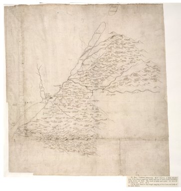
Description:
|
A map of Lochaber, from Loch Lochy and the River Spean, southwest to Loch Linnhe, Loch Leven and Glen Coe. Much of the content is of hills, trees and rivers drawn diagrammatically, except that Ben Nevis is given prominence. The map was compiled by Robert Gordon of Straloch (1580-1661), at an unknown date after 1633. The main source of the compilation is likely to be the observations of Timothy Pont, in the last two decades of the sixteenth century, although a map by Pont, covering a part of Gordon's map and now in the National Library of Scotland, shows many differences.
|
|
Work Type:
|
Manuscript map/plan
|
|
Measurement:
|
35 x 37.5cm (1' 1 3/4" x 1' 2 3/4")
|
|
Material:
|
Paper
|
|
Technique:
|
Pen and ink
|
|
Subject Place:
|
Glen Coe
|
|
Subject Place:
|
Inverness-shire
|
|
Subject Place:
|
Loch Linnhe
|
|
Subject Place:
|
Loch Lochy
|
|
Subject Place:
|
Lochaber
|
|
Subject Place:
|
Scotland
|
|
Reference:
|
Taylor, Alexander B., 'Manuscript maps of Pont, the Gordons and Adair in the Advocates' Library, Edinburgh',Scottish Geographical Magazine, Nov., 1907, p.588.
|
|
Rights Statement:
|
© 2002 The National Library of Scotland
|
|
Repro File Type:
|
Cropped Tiff
|
|
Repro File Size (bytes):
|
99484840
|
|
Repro Notes:
|
37
|
|
Repro Title:
|
Lochabre Glencooen [1 of 2]
|
|
Repro Display Measurement (pixels):
|
7072 x 7072
|
|
Repro ID Number:
|
0042401c.tif
|
|
Repro Old ID Number:
|
00000555
|
|
Repro Capture Date:
|
07/06/2000 15:00:00
|