Detail View: Charting The Nation: Part of Aberdeen Shyre [1 of 1]
|
Work Record ID:
|
0042399
|
|
Shelfmark:
|
Adv.MS.70.2.10 (Gordon 34)
|
|
Holding Institution:
|
National Library of Scotland
|
|
Title:
|
Part of Aberdeen Shyre
|
|
Creator:
|
Pont, Timothy (b.1564, d.Circa 1614)
|
|
Creator Role:
|
Surveyor
|
|
Creator:
|
Gordon, Robert (b.1580, d.1661)
|
|
Creator Role:
|
Mapmaker
|
|
Date:
|
1634-1655
|
|
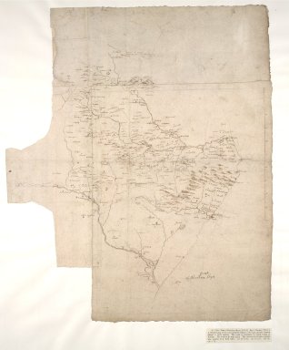
Description:
|
A large scale map of part of Buchan. Coverage extends from the North Ugie Water to the Ythan River, as far west as Fyvie. This part of the country was close to the home of the author, Robert Gordon of Straloch (1580-1661). The draft appears to be unfinished. The coverage overlaps in part with a map in the National Library of Scotland compiled by Timothy Pont in the last two decades of the sixteenth century. Pont's observations on the ground may in part be the source of Gordon's map, but they are not the only source, since the map does contain original information.
|
|
Work Type:
|
Manuscript map/plan
|
|
Measurement:
|
44.7 x 53.4cm (1' 5 5/8" x 1' 9")
|
|
Material:
|
Paper
|
|
Technique:
|
Pen and ink
|
|
Subject Place:
|
Aberdeenshire
|
|
Subject Place:
|
Buchan
|
|
Subject Place:
|
Scotland
|
|
Reference:
|
Taylor, Alexander B., 'Manuscript maps of Pont, the Gordons and Adair in the Advocates' Library, Edinburgh',Scottish Geographical Magazine, Nov., 1907, p.588.
|
|
Rights Statement:
|
© 2002 The National Library of Scotland
|
|
Repro File Type:
|
Cropped Tiff
|
|
Repro File Size (bytes):
|
115348142
|
|
Repro Notes:
|
34
|
|
Repro Title:
|
Part of Aberdeen Shyre [1 of 1]
|
|
Repro Display Measurement (pixels):
|
7072 x 7072
|
|
Repro ID Number:
|
0042399c.tif
|
|
Repro Old ID Number:
|
00000552
|
|
Repro Capture Date:
|
07/06/2000 13:55:00
|